
Thank you for supporting this site ❤️
Make a donation
Make a donation
Quitumbe topographic map
Click on the map to display elevation.
Thank you for supporting this site ❤️
Make a donation
Make a donation
About this map
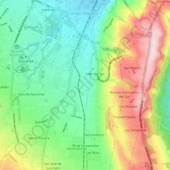
Name: Quitumbe topographic map, elevation, terrain.
Location: Quitumbe, Quito, Quito Canton, Pichincha, Ecuador (-0.32791 -78.55938 -0.27927 -78.51298)
Average elevation: 2,985 m
Minimum elevation: 2,854 m
Maximum elevation: 3,183 m
Thank you for supporting this site ❤️
Make a donation
Make a donation
Other topographic maps
Click on a map to view its topography, its elevation and its terrain.