
Thank you for supporting this site ❤️
Make a donation
Make a donation
Youngwood topographic map
Click on the map to display elevation.
Thank you for supporting this site ❤️
Make a donation
Make a donation
About this map
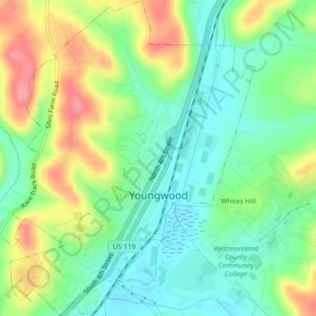
Name: Youngwood topographic map, elevation, terrain.
Average elevation: 319 m
Minimum elevation: 283 m
Maximum elevation: 379 m
Thank you for supporting this site ❤️
Make a donation
Make a donation
Other topographic maps
Click on a map to view its topography, its elevation and its terrain.
Five Points
United States > Pennsylvania > Westmoreland County > Salem Township > Five Points
Average elevation: 385 m