
Wörth am Rhein topographic map
Interactive map
Click on the map to display elevation.
About this map
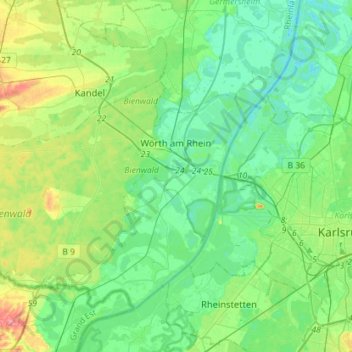
Name: Wörth am Rhein topographic map, elevation, terrain.
Average elevation: 115 m
Minimum elevation: 93 m
Maximum elevation: 179 m
Other topographic maps
Click on a map to view its topography, its elevation and its terrain.
Knittelsheim
Germany > Rhineland-Palatinate > Landkreis Germersheim > Knittelsheim
Knittelsheim, Bellheim, Landkreis Germersheim, Rhineland-Palatinate, Germany
Average elevation: 125 m
Germersheim
Germany > Rhineland-Palatinate > Landkreis Germersheim
Germersheim, Landkreis Germersheim, Rhineland-Palatinate, 76726, Germany
Average elevation: 104 m