
Thank you for supporting this site ❤️
Make a donation
Make a donation
Las Cruces topographic map
Click on the map to display elevation.
Thank you for supporting this site ❤️
Make a donation
Make a donation
Las Cruces
The approximate elevation of Las Cruces is 3,908 feet (1,191 m) above mean sea level.
Thank you for supporting this site ❤️
Make a donation
Make a donation
About this map
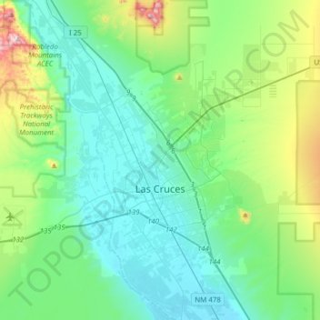
Name: Las Cruces topographic map, elevation, terrain.
Location: Las Cruces, Doña Ana County, New Mexico, United States (32.24229 -106.97329 32.43187 -106.66567)
Average elevation: 1,297 m
Minimum elevation: 1,174 m
Maximum elevation: 1,772 m
Thank you for supporting this site ❤️
Make a donation
Make a donation
Other topographic maps
Click on a map to view its topography, its elevation and its terrain.
White Sands Missile Range
United States > New Mexico > Doña Ana County > White Sands
Average elevation: 1,306 m
Thank you for supporting this site ❤️
Make a donation
Make a donation
White Sands Missile Range
United States > New Mexico > Doña Ana County > White Sands
Average elevation: 1,306 m