
Thank you for supporting this site ❤️
Make a donation
Make a donation
Opperode topographic map
Click on the map to display elevation.
Thank you for supporting this site ❤️
Make a donation
Make a donation
About this map
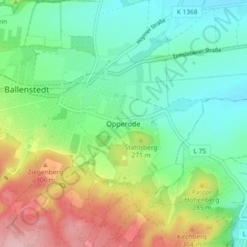
Name: Opperode topographic map, elevation, terrain.
Average elevation: 235 m
Minimum elevation: 175 m
Maximum elevation: 353 m
Thank you for supporting this site ❤️
Make a donation
Make a donation
Other topographic maps
Click on a map to view its topography, its elevation and its terrain.
Rieder
Deutschland > Sachsen-Anhalt > Landkreis Harz > Ballenstedt
Durch günstige geobiologische Bedingungen kam bereits in der Renaissance der Gartenbau zu voller Blüte. Vor dem Zweiten Weltkrieg war Rieder das größte Blumendorf Deutschlands. Die Roseburg gehört heute zum Projekt Gartenträume Sachsen-Anhalt. Östlich von Rieder befindet sich der Schierberg mit dem…
Average elevation: 265 m