
Thank you for supporting this site ❤️
Make a donation
Make a donation
Mettur topographic map
Click on the map to display elevation.
Thank you for supporting this site ❤️
Make a donation
Make a donation
About this map
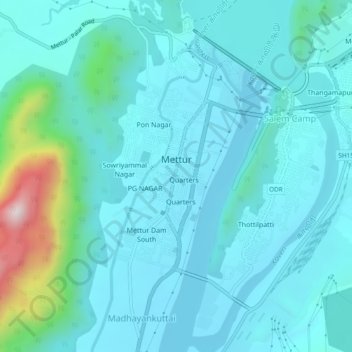
Name: Mettur topographic map, elevation, terrain.
Location: Mettur, Salem District, Tamil Nadu, India (11.76638 77.78738 11.80972 77.83490)
Average elevation: 276 m
Minimum elevation: 188 m
Maximum elevation: 818 m
Thank you for supporting this site ❤️
Make a donation
Make a donation
Other topographic maps
Click on a map to view its topography, its elevation and its terrain.