
Gorno topographic map
Interactive map
Click on the map to display elevation.
Gorno
The municipality is located in the lower part of the Val del Riso, a valley that starts east of the Colle di Zambla and descends opening westward, flowing into the wider Val Seriana. The territory draws an irregular geometric profile, with very pronounced elevation variations. The altitude of the municipal territory ranges between a minimum altitude of 475 m a.s.l. in the locality of Centrale (at the entrance of the town) and a maximum altitude of 1,775 m a.s.l. in the locality of Preda Balaranda, with a difference in altitude of 1,300 m characterized in the upper part by a very wide and suggestive panoramic opening offered by the surrounding Orobic mountains.
About this map
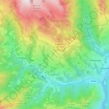
Name: Gorno topographic map, elevation, terrain.
Location: Gorno, Bergamo, Lombardy, Italy (45.84498 9.82124 45.90170 9.86665)
Average elevation: 968 m
Minimum elevation: 431 m
Maximum elevation: 1,917 m
Other topographic maps
Click on a map to view its topography, its elevation and its terrain.