
Urdorf topographic map
Interactive map
Click on the map to display elevation.
About this map
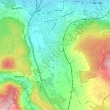
Name: Urdorf topographic map, elevation, terrain.
Location: Urdorf, Bezirk Dietikon, Zürich, 8902, Schweiz (47.36543 8.39956 47.39648 8.44801)
Average elevation: 475 m
Minimum elevation: 392 m
Maximum elevation: 614 m
Other topographic maps
Click on a map to view its topography, its elevation and its terrain.
Birmensdorf (ZH)
Schweiz > Zürich > Bezirk Dietikon
Birmensdorf (ZH), Bezirk Dietikon, Zürich, 8903, Schweiz
Average elevation: 554 m
Oberengstringen
Schweiz > Zürich > Bezirk Dietikon
Oberengstringen, Bezirk Dietikon, Zürich, 8102, Schweiz
Average elevation: 462 m
Schlieren
Schweiz > Zürich > Bezirk Dietikon > Schlieren
Schlieren, Bezirk Dietikon, Zürich, 8952, Schweiz
Average elevation: 440 m