
Thank you for supporting this site ❤️
Make a donation
Make a donation
Cedarcreek topographic map
Click on the map to display elevation.
Thank you for supporting this site ❤️
Make a donation
Make a donation
About this map
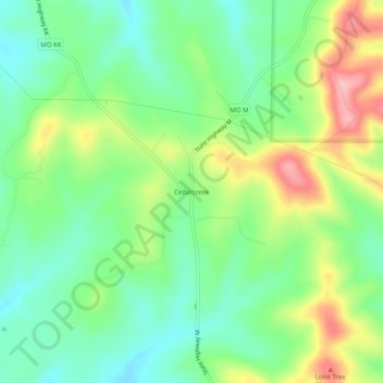
Name: Cedarcreek topographic map, elevation, terrain.
Location: Cedarcreek, Taney County, Missouri, 65627, United States (36.55895 -93.01768 36.59895 -92.97768)
Average elevation: 306 m
Minimum elevation: 254 m
Maximum elevation: 396 m
Thank you for supporting this site ❤️
Make a donation
Make a donation
Other topographic maps
Click on a map to view its topography, its elevation and its terrain.