
Rahal topographic map
Interactive map
Click on the map to display elevation.
About this map
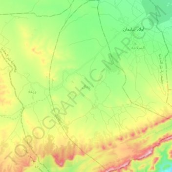
Name: Rahal topographic map, elevation, terrain.
Location: Rahal, Bir El Hafey, Sidi Bouzid, Tunisie (34.73209 9.30672 34.84920 9.42229)
Average elevation: 418 m
Minimum elevation: 302 m
Maximum elevation: 601 m
Other topographic maps
Click on a map to view its topography, its elevation and its terrain.
El Ayoun
El Ayoun, Cebalet Ouled Asker, Sidi Bouzid, Tunisie
Average elevation: 636 m
El Boua
Tunisie > Sidi Bouzid > El Boua
El Boua, Essed, Mezzouna, Sidi Bouzid, 9154, Tunisie
Average elevation: 93 m
El Kharrouba
El Kharrouba, Menzel Bouzaïane, Sidi Bouzid, Tunisie
Average elevation: 298 m
Parc National de Bou Hedma
Parc National de Bou Hedma, RR 124 طج, Et-Talh Est, Belkhir, Sidi Bouzid, Tunisie
Average elevation: 125 m