
Thank you for supporting this site ❤️
Make a donation
Make a donation
Ifafi topographic map
Click on the map to display elevation.
Thank you for supporting this site ❤️
Make a donation
Make a donation
About this map
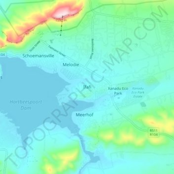
Name: Ifafi topographic map, elevation, terrain.
Average elevation: 1,230 m
Minimum elevation: 1,159 m
Maximum elevation: 1,593 m
Thank you for supporting this site ❤️
Make a donation
Make a donation
Other topographic maps
Click on a map to view its topography, its elevation and its terrain.
Magalies
South Africa > North West > Bojanala Platinum District Municipality > Madibeng Local Municipality
Average elevation: 1,297 m