
Make a donation
Mandandeupur topographic map
Click on the map to display elevation.
Make a donation
About this map
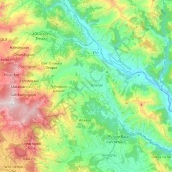
Name: Mandandeupur topographic map, elevation, terrain.
Location: Mandandeupur, Kavrepalanchok, Bagamati Province, 45213, Nepal (27.65860 85.51915 27.75706 85.69442)
Average elevation: 1,149 m
Minimum elevation: 644 m
Maximum elevation: 2,142 m
Make a donation
Other topographic maps
Click on a map to view its topography, its elevation and its terrain.
Nagarkot
Nepal > Bagamati Province > Kavrepalanchok
At the time of the 2021 census it had a population of 5,234 and had 1,084 houses in it. At an elevation of 2,195 meters, it is considered one of the most scenic spots in Bhaktapur District. Nagarkot also offers views of the Kathmandu Valley. The scenery of the place makes it a popular hiking route for…
Average elevation: 1,679 m
Make a donation
Nagarkot
Nepal > Bagamati Province > Kavrepalanchok
Nagarkot (Nepali: नगरकोट) is a former village development committee located 32 km east of Kathmandu, Nepal, in Bhaktapur District in Bagmati Province and as of 2015 part of Nagarkot Municipality. At the time of the 2011 census it had a population of 4,571 and had 973 houses in it. At an elevation…
Average elevation: 1,679 m
Make a donation
Panorama of Banepa Valley & Himalaya Mountains
Nepal > Bagamati Province > Kavrepalanchok
Average elevation: 1,611 m
Make a donation