
Thank you for supporting this site ❤️
Make a donation
Make a donation
Georgia topographic map
Click on the map to display elevation.
Thank you for supporting this site ❤️
Make a donation
Make a donation
About this map
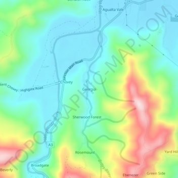
Name: Georgia topographic map, elevation, terrain.
Location: Georgia, Saint Mary, Middlesex County, Jamaica (18.22674 -76.82366 18.26674 -76.78366)
Average elevation: 112 m
Minimum elevation: 3 m
Maximum elevation: 365 m
Thank you for supporting this site ❤️
Make a donation
Make a donation
Other topographic maps
Click on a map to view its topography, its elevation and its terrain.