
Thank you for supporting this site ❤️
Make a donation
Make a donation
Chorente topographic map
Click on the map to display elevation.
Thank you for supporting this site ❤️
Make a donation
Make a donation
About this map
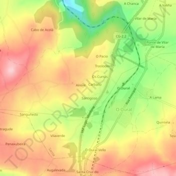
Name: Chorente topographic map, elevation, terrain.
Location: Chorente, Sarria, Lugo, Galiza, 27392, Espanha (42.70591 -7.48275 42.73619 -7.43799)
Average elevation: 626 m
Minimum elevation: 513 m
Maximum elevation: 712 m
Thank you for supporting this site ❤️
Make a donation
Make a donation
Other topographic maps
Click on a map to view its topography, its elevation and its terrain.