
Thank you for supporting this site ❤️
Make a donation
Make a donation
Paal Dua topographic map
Click on the map to display elevation.
Thank you for supporting this site ❤️
Make a donation
Make a donation
About this map
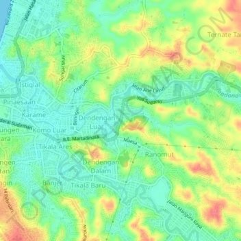
Name: Paal Dua topographic map, elevation, terrain.
Location: Paal Dua, Manado, North Sulawesi, Sulawesi, 95127, Indonesia (1.46993 124.84201 1.50993 124.88201)
Average elevation: 27 m
Minimum elevation: 0 m
Maximum elevation: 68 m
Thank you for supporting this site ❤️
Make a donation
Make a donation
Other topographic maps
Click on a map to view its topography, its elevation and its terrain.