
Make a donation
Marchastel topographic map
Click on the map to display elevation.
Make a donation
About this map
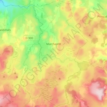
Name: Marchastel topographic map, elevation, terrain.
Average elevation: 1,228 m
Minimum elevation: 1,077 m
Maximum elevation: 1,382 m
Make a donation
Other topographic maps
Click on a map to view its topography, its elevation and its terrain.
Make a donation
Make a donation
Make a donation
Make a donation
Make a donation
Make a donation
Make a donation
Pic Cassini
France > Occitanie > Lozère > Pont de Montvert - Sud Mont Lozère
Average elevation: 1,539 m
Make a donation
Make a donation
Signal de Randon
France > Occitanie > Lozère > Monts-de-Randon
L'étage montagnard supérieur s'étend de 1 250 à 1 450 m et est principalement composé d'une hêtraie d’altitude acidiphile. Au-dessus de 1 450 m, l'étage subalpin présente une lande à callune et myrtille.
Average elevation: 1,454 m
Sommet de Finiels
France > Occitanie > Lozère > Pont de Montvert - Sud Mont Lozère
La position et l'altitude de ce point permettent par temps très clair de voir la chaîne des Alpes à l'est, la mer Méditerranée au sud et le Plomb du Cantal au nord-ouest.
Average elevation: 1,571 m
Make a donation
Mijavols
France > Occitanie > Lozère > Cans et Cévennes > Saint-Julien-d'Arpaon
Average elevation: 1,038 m
Make a donation
Make a donation
Mas de la Barque
France > Occitanie > Lozère > Pont de Montvert - Sud Mont Lozère
Average elevation: 1,410 m
La Baraque de Trémolet
France > Occitanie > Lozère > Massegros Causses Gorges
Average elevation: 855 m
Make a donation
Le Malzieu-Forain
France > Occitanie > Lozère > Le Malzieu-Forain > Le Malzieu-Forain
Average elevation: 1,053 m
Gorges du Tarn
France > Occitanie > Lozère > Gorges du Tarn Causses > Sainte-Enimie
Average elevation: 781 m
Lac de Charpal
France > Occitanie > Lozère > Arzenc-de-Randon
Le lac de Charpal se situe à 1 326 m d'altitude, sur le socle granitique du plateau du Palais-du-Roi, dépendance Sud du massif de la Margeride, dans un secteur affaissé entre des failles par rapport aux sommets granitiques qui le dominent (1 553 m). En effet, on observe aux appuis du barrage un grès…
Average elevation: 1,345 m
Make a donation
La Brousse
France > Occitanie > Lozère > Pont de Montvert - Sud Mont Lozère
Average elevation: 1,290 m
Make a donation
Orme champêtre du causse Méjean
France > Occitanie > Lozère > Saint-Pierre-des-Tripiers
Average elevation: 921 m
Make a donation
Make a donation
Make a donation
Make a donation
Les Vignes
France > Occitanie > Lozère > Massegros Causses Gorges
Le village est construit au bord du Tarn, sur les flancs du plateau calcaire du causse de Sauveterre, face au causse Méjean, à environ 400 m d'altitude.
Average elevation: 778 m
Make a donation
Make a donation
Make a donation
Make a donation
Make a donation
Make a donation