
Make a donation
Sorsogon City topographic map
Click on the map to display elevation.
Make a donation
Sorsogon City
Sorsogon City covers a land area of 31,292 hectares (120.82 sq mi). It is at the southernmost tip of the Bicol Peninsula and of Luzon Island. The city is bounded by Castilla in the west, Manito in the northwest, Albay Gulf in the north, Prieto Diaz in the east, Gubat in the southeast, Casiguran in the southwest, and Sorsogon Bay in the south. Sorsogon is characterized by an irregular topography; mountain ranges on the north-west, sloping uplands on the central part of the city, plain areas southwestern and central north and southeast portion, and marshlands on the southeast deltas. It is also surrounded by water, with Sorsogon Bay to the west Albay Gulf to the northeast, and Philippine Sea in the east.
Make a donation
About this map
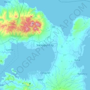
Name: Sorsogon City topographic map, elevation, terrain.
Location: Sorsogon City, Sorsogon, Bicol Region, 4700, Philippines (12.81078 123.84525 13.13078 124.16525)
Average elevation: 89 m
Minimum elevation: -3 m
Maximum elevation: 1,064 m
Make a donation