
Brestov topographic map
Interactive map
Click on the map to display elevation.
About this map
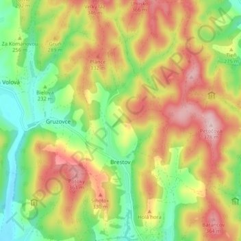
Name: Brestov topographic map, elevation, terrain.
Location: Brestov, District of Humenné, Region of Prešov, Slovakia (48.94755 21.87515 48.99995 21.91222)
Average elevation: 262 m
Minimum elevation: 150 m
Maximum elevation: 386 m
The municipality lies at an altitude of 206 metres and covers an area of 10.122 km². It has a population of about 545 people.
Other topographic maps
Click on a map to view its topography, its elevation and its terrain.
Modra nad Cirochou
Slovakia > Region of Prešov > District of Humenné
Modra nad Cirochou, District of Humenné, Region of Prešov, Slovakia
Average elevation: 264 m