
Thank you for supporting this site ❤️
Make a donation
Make a donation
Qiaoxi District topographic map
Click on the map to display elevation.
Thank you for supporting this site ❤️
Make a donation
Make a donation
About this map
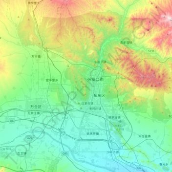
Name: Qiaoxi District topographic map, elevation, terrain.
Location: Qiaoxi District, Zhangjiakou, Hebei, 075000, China (40.64334 114.75792 40.96408 114.96722)
Average elevation: 917 m
Minimum elevation: 618 m
Maximum elevation: 1,764 m
Thank you for supporting this site ❤️
Make a donation
Make a donation
Other topographic maps
Click on a map to view its topography, its elevation and its terrain.