
Make a donation
Coahuila topographic map
Click on the map to display elevation.
Make a donation
Coahuila
The Sierra Madre Oriental runs northwest to southeast through the State, and the higher elevations are home to the Sierra Madre Oriental pine-oak forests. The northernmost fingers of the Sierra Madre Oriental, the Sierra del Burro and the Sierra del Carmen, reach to the border with the United States at the Rio Grande.
Make a donation
About this map
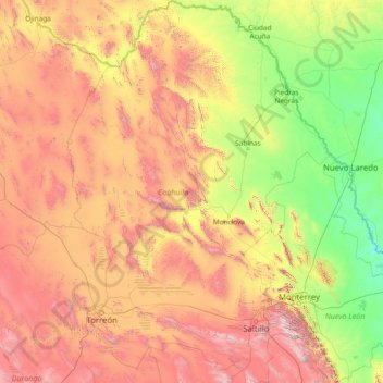
Name: Coahuila topographic map, elevation, terrain.
Location: Coahuila, Mexico (24.54268 -103.96000 29.88003 -99.84288)
Average elevation: 1,009 m
Minimum elevation: 61 m
Maximum elevation: 3,619 m
Make a donation
Other topographic maps
Click on a map to view its topography, its elevation and its terrain.
Make a donation
Ciudad Juárez
Due to its location in the Chihuahuan Desert and high altitude, Ciudad Juárez has a cold desert climate (Köppen: BWk). Seasons are distinct, with hot summers, mild springs and autumns, and cold winters. Summer average high is 35 °C (95 °F) with lows of 21 °C (70 °F). Winter highs average 14 °C (57 °F)…
Average elevation: 1,228 m
Make a donation
Villahermosa
Villahermosa is located in the southeast of Mexico between the rivers Grijalva and Carrizal. The average elevation of the city is 10 meters above sea level. The city also has several lagoons, the largest and most important of them being La Laguna de las Ilusiones (Illusions Lagoon).
Average elevation: 9 m
Make a donation
Acapulco
Mexico > Guerrero > Acapulco de Juárez
The city, located on the Pacific coast of Mexico in the state of Guerrero, is classified as one of the state's seven regions, dividing the rest of the Guerrero coast into the Costa Grande and the Costa Chica. Forty percent of the municipality is mountainous terrain; another forty percent is semi-flat; and the…
Average elevation: 99 m
Make a donation
Make a donation
Make a donation