
Macherla topographic map
Interactive map
Click on the map to display elevation.
About this map
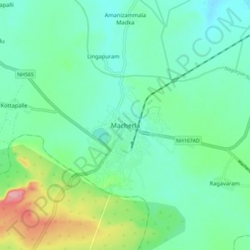
Name: Macherla topographic map, elevation, terrain.
Location: Macherla, Guntur, Andhra Pradesh, 522426, India (16.43611 79.39641 16.51611 79.47641)
Average elevation: 156 m
Minimum elevation: 125 m
Maximum elevation: 246 m
Macherla is located at 16°29′N 79°26′E / 16.48°N 79.43°E / 16.48; 79.43. It has an average elevation of 136 metres (446 feet). It is located 23 kilometers from Nagarjuna Sagar. Jerri Vagu is the source of water for the town and the surrounding villages.