Geolocate

Einhausen topographic map

Interactive map

Click on the map to display elevation.

About this map

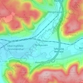
Name: Einhausen topographic map, elevation, terrain.

Location: Einhausen, Dolmar-Salzbrücke, Landkreis Schmalkalden-Meiningen, Thuringia, Germany (50.51219 10.44815 50.55140 10.49101)

Average elevation: 379 m

Minimum elevation: 293 m

Maximum elevation: 509 m

Other topographic maps

Click on a map to view its topography, its elevation and its terrain.

Petrus (12. Apostel)

Germany > Thuringia > Landkreis Schmalkalden-Meiningen > Steinbach-Hallenberg

Petrus (12. Apostel), Steinbach-Hallenberg, Landkreis Schmalkalden-Meiningen, Thuringia, Germany

Average elevation: 704 m

Kaltensundheim

Germany > Thuringia > Landkreis Schmalkalden-Meiningen > Kaltennordheim

Kaltensundheim, Kaltennordheim, Hohe Rhön, Landkreis Schmalkalden-Meiningen, Thuringia, 36542, Germany

Average elevation: 513 m

Kerbe

Germany > Thuringia > Landkreis Schmalkalden-Meiningen > Steinbach-Hallenberg > Viernau

Kerbe, Viernau, Steinbach-Hallenberg, Landkreis Schmalkalden-Meiningen, Thuringia, 98587, Germany

Average elevation: 447 m

Oberhof

Germany > Thuringia > Landkreis Schmalkalden-Meiningen

Oberhof, Landkreis Schmalkalden-Meiningen, Thuringia, 98559, Germany

Average elevation: 749 m