
Make a donation
Fuxin City topographic map
Click on the map to display elevation.
Make a donation
About this map
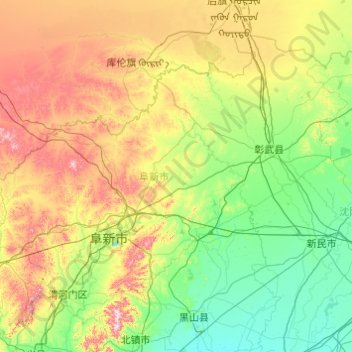
Name: Fuxin City topographic map, elevation, terrain.
Location: Fuxin City, Liaoning, China (41.69075 121.02275 42.84138 122.96855)
Average elevation: 193 m
Minimum elevation: 11 m
Maximum elevation: 796 m
Make a donation
Other topographic maps
Click on a map to view its topography, its elevation and its terrain.
Make a donation
Make a donation
Make a donation
Make a donation
Make a donation
Anshan
China > Liaoning > Shengli Subdistrict
Local transportation is primarily by bus or taxi. Anshan used to have a single tram line—along Zhonghua Avenue, through the city centre and past Angang main gate—but this has been closed and the tracks removed. Due to the flat topography of the city centre, bicycles are popular. Almost all roads have a…
Average elevation: 79 m
Hongqiyingzi
China > Liaoning > Xiuyan Manchu Autonomous County > Hongqiyingzi
Average elevation: 169 m
Make a donation