
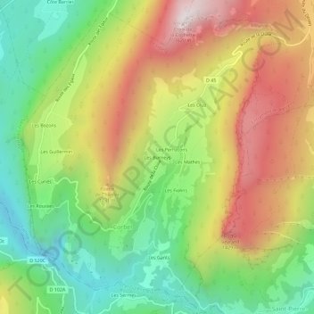
Les Burneys topographic map
Interactive map
Click on the map to display elevation.
About this map
Name: Les Burneys topographic map, elevation, terrain.
Average elevation: 969 m
Minimum elevation: 467 m
Maximum elevation: 1,590 m
Other topographic maps
Click on a map to view its topography, its elevation and its terrain.
Les Bozons
France > Auvergne-Rhône-Alpes > Savoie > Corbel > Les Bozons
Les Bozons, Corbel, Chambéry, Savoie, Auvergne-Rhône-Alpes, France métropolitaine, 73160, France
Average elevation: 785 m