
San Pedro de Casta topographic map
Interactive map
Click on the map to display elevation.
About this map
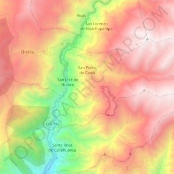
Name: San Pedro de Casta topographic map, elevation, terrain.
Location: San Pedro de Casta, Provincia de Huarochirí, Lima, Perú (-11.81668 -76.62733 -11.73156 -76.47288)
Average elevation: 3,257 m
Minimum elevation: 1,327 m
Maximum elevation: 4,804 m
Other topographic maps
Click on a map to view its topography, its elevation and its terrain.
Marcahuasi
Perú > Lima > San Pedro de Casta
Marcahuasi, San Pedro de Casta, Huarochirí, Lima, Perú
Average elevation: 3,787 m