
Thank you for supporting this site ❤️
Make a donation
Make a donation
Chukha District topographic map
Click on the map to display elevation.
Thank you for supporting this site ❤️
Make a donation
Make a donation
About this map
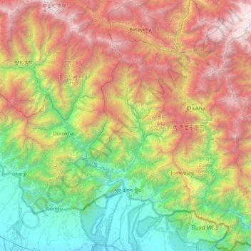
Name: Chukha District topographic map, elevation, terrain.
Location: Chukha District, Bhutan (26.71751 89.26415 27.31443 89.79040)
Average elevation: 1,827 m
Minimum elevation: 99 m
Maximum elevation: 4,696 m
Thank you for supporting this site ❤️
Make a donation
Make a donation
Other topographic maps
Click on a map to view its topography, its elevation and its terrain.
Jigmecholing town
Bhutan > Sarpang District > Jigme Chhoeling Gewog > Khamaed
Average elevation: 1,216 m
Thank you for supporting this site ❤️
Make a donation
Make a donation
Deothang
Bhutan > Samdrup Jongkhar District > Dewathang Gewog > Chhenangri_Rishor > Deothang
Average elevation: 660 m