
Laramie topographic map
Interactive map
Click on the map to display elevation.
About this map
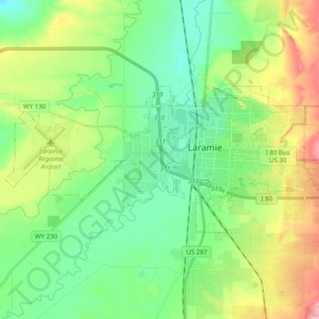
Name: Laramie topographic map, elevation, terrain.
Location: Laramie, Albany County, Wyoming, États-Unis d'Amérique (41.27742 -105.69729 41.33581 -105.52819)
Average elevation: 2,219 m
Minimum elevation: 2,166 m
Maximum elevation: 2,462 m
Other topographic maps
Click on a map to view its topography, its elevation and its terrain.
Laramie
États-Unis d'Amérique > Wyoming > Albany County > Laramie
Laramie, Albany County, Wyoming, 82070, États-Unis d'Amérique
Average elevation: 2,299 m