Dayton topographic map
Interactive map
Click on the map to display elevation.
About this map
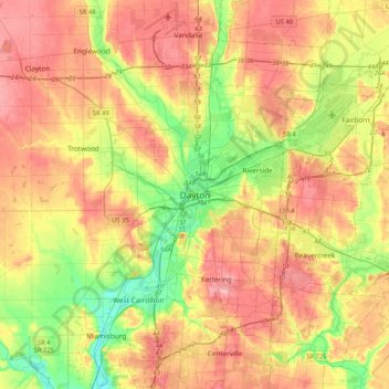
Name: Dayton topographic map, elevation, terrain.
Location: Dayton, Montgomery County, Ohio, 45423, United States (39.59895 -84.35161 39.91895 -84.03161)
Average elevation: 270 m
Minimum elevation: 206 m
Maximum elevation: 332 m
Other topographic maps
Click on a map to view its topography, its elevation and its terrain.
Patterson
United States > Ohio > Montgomery County > Dayton
Patterson, Dayton, Montgomery County, Ohio, 45408, United States
Average elevation: 233 m
Residence Park
United States > Ohio > Montgomery County > Dayton
Residence Park, Dayton, Montgomery County, Ohio, 45428, United States
Average elevation: 266 m
West Side
United States > Ohio > Montgomery County > Dayton
West Side, Dayton, Montgomery County, Ohio, 45407, United States
Average elevation: 232 m
Crown Point
United States > Ohio > Montgomery County > Dayton > Crown Point
Crown Point, Dayton, Montgomery County, Ohio, 45428, United States
Average elevation: 273 m