
Zeltingen-Rachtig topographic map
Interactive map
Click on the map to display elevation.
About this map
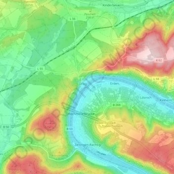
Name: Zeltingen-Rachtig topographic map, elevation, terrain.
Average elevation: 215 m
Minimum elevation: 96 m
Maximum elevation: 419 m
Other topographic maps
Click on a map to view its topography, its elevation and its terrain.
Moezel
Duitsland > Rijnland-Palts > Landkreis Bernkastel-Wittlich > Zeltingen-Rachtig
Moezel, Zeltingen-Rachtig, Bernkastel-Kues, Landkreis Bernkastel-Wittlich, Rijnland-Palts, 54492, Duitsland
Average elevation: 203 m