
Salux topographic map
Interactive map
Click on the map to display elevation.
About this map
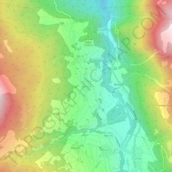
Name: Salux topographic map, elevation, terrain.
Location: Salux, Surses, Albula, Graubünden, 7462, Schweiz (46.60437 9.55532 46.64437 9.59532)
Average elevation: 1,447 m
Minimum elevation: 981 m
Maximum elevation: 2,129 m
Auf dem ehemaligen Gemeindegebiet von Salouf liegt Ziteil, das höchstgelegene Gotteshaus Europas. Die Wallfahrtskirche mit Pilgerhaus steht auf einer Höhe von 2429 m ü. M. Der Legende nach gab es im Sommer 1580 zwei Maria-Erscheinungen. Wahrscheinlich schon kurz nach der zweiten Erscheinung wurde in Ziteil eine bescheidene Kapelle gebaut. Die heutige Kirche stammt aus dem Jahr 1848, wurde im Jahr 1957 vergrössert und 1977 erneut aufgestockt. Sie ist somit in ihrem Ursprung weitgehend nicht mehr erhalten.
Other topographic maps
Click on a map to view its topography, its elevation and its terrain.
Julierpass
Schweiz > Graubünden > Albula > Surses
Julierpass, Surses, Albula, Graubünden, Schweiz
Average elevation: 2,444 m
Savognin
Schweiz > Graubünden > Albula > Surses
Savognin, Surses, Albula, Graubünden, 7460, Schweiz
Average elevation: 1,461 m