
Vittorio Veneto topographic map
Interactive map
Click on the map to display elevation.
About this map
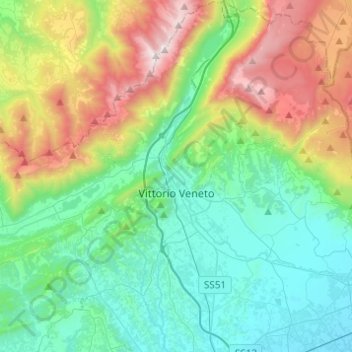
Name: Vittorio Veneto topographic map, elevation, terrain.
Location: Vittorio Veneto, Treviso, Veneto, Italië (45.91287 12.24380 46.08290 12.36215)
Average elevation: 525 m
Minimum elevation: 38 m
Maximum elevation: 1,751 m
Other topographic maps
Click on a map to view its topography, its elevation and its terrain.
Monte Baldo
Monte Baldo, Revine Lago, Treviso, Veneto, 31029, Italië
Average elevation: 312 m
Valdobbiadene
Valdobbiadene, Treviso, Veneto, 31049, Italië
Average elevation: 548 m
Le Marche
Italië > Veneto > Treviso > Breda di Piave
Le Marche, Breda di Piave, Treviso, Veneto, 31048, Italië
Average elevation: 17 m