
Municipio de La Paz topographic map
Interactive map
Click on the map to display elevation.
About this map
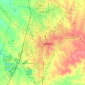
Name: Municipio de La Paz topographic map, elevation, terrain.
Location: Municipio de La Paz, Canelones, Uruguay (-34.77010 -56.32443 -34.68202 -56.21470)
Average elevation: 50 m
Minimum elevation: -1 m
Maximum elevation: 93 m
Other topographic maps
Click on a map to view its topography, its elevation and its terrain.
Aeropuerto Internacional de Carrasco
Uruguay > Canelones > Aeropuerto Internacional de Carrasco
Aeropuerto Internacional de Carrasco, Municipio de Paso Carrasco, Canelones, 14000, Uruguay
Average elevation: 17 m