
Make a donation
Ravenna topographic map
Click on the map to display elevation.
Make a donation
About this map
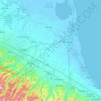
Name: Ravenna topographic map, elevation, terrain.
Location: Ravenna, Emilia-Romagna, Italy (44.09910 11.52494 44.62834 12.38397)
Average elevation: 60 m
Minimum elevation: -7 m
Maximum elevation: 777 m
Make a donation
Other topographic maps
Click on a map to view its topography, its elevation and its terrain.
Monte Cusna
Italy > Emilia-Romagna > Reggio nell'Emilia > Villa Minozzo
The mountain is located along the Appennino Crest Trail (A00) between Cerreto and Lagastrello Passes, with an altitude of 2,120 metres (6,960 ft). It is also known as Uomo Morto (Italian: "Dead Man"), "Uomo che Dorme" ("Sleeping Man") or "Il Gigante" ("The Giant") for its appearance, resembling a lying man.
Average elevation: 1,721 m
Bologna
Italy > Emilia-Romagna > Bologna > Bologna
Bologna is situated on the edge of the Po Plain at the foot of the Apennine Mountains, at the meeting of the Reno and Savena river valleys. As Bologna's two main watercourses flow directly to the sea, the town lies outside of the drainage basin of the River Po. The Province of Bologna stretches from the…
Average elevation: 118 m
Make a donation