
Jalalabat topographic map
Interactive map
Click on the map to display elevation.
About this map
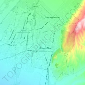
Name: Jalalabat topographic map, elevation, terrain.
Location: Jalalabat, Jalal-Abad Region, Kyrgyzstan (40.90280 72.94368 40.96571 73.03471)
Average elevation: 779 m
Minimum elevation: 719 m
Maximum elevation: 990 m
One of Kyrgyzstan's main branches of the Silk Road passed through Jalalabat and the region has played host to travelers for thousands of years, although few archaeological remains are visible today – except in some of the more remote parts of the region – such as Saimalu Tash and the Chatkal valley. These have included travelers, traders, tourists and pilgrims (to the various holy sights) and sick people visiting the curative spas such as in the Ayub Tau mountain, at the altitude of 700 m above sea level some three kilometers out of town.
Other topographic maps
Click on a map to view its topography, its elevation and its terrain.
Toktogul
Kyrgyzstan > Jalal-Abad Region > Toktogul
Toktogul, Jalal-Abad Region, Kyrgyzstan
Average elevation: 978 m
Sary-Chelek
Kyrgyzstan > Jalal-Abad Region
Sary-Chelek, Jalal-Abad Region, Kyrgyzstan
Average elevation: 2,620 m
Chatkal ridge
Kyrgyzstan > Jalal-Abad Region
Chatkal ridge, Jalal-Abad Region, Kyrgyzstan
Average elevation: 2,463 m