
Porto Brandão topographic map
Interactive map
Click on the map to display elevation.
About this map
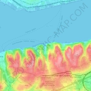
Name: Porto Brandão topographic map, elevation, terrain.
Average elevation: 40 m
Minimum elevation: 0 m
Maximum elevation: 122 m
Other topographic maps
Click on a map to view its topography, its elevation and its terrain.
Charneca de Caparica
Charneca de Caparica, Almada, Setúbal, Portugal
Average elevation: 34 m
Laranjeiro
Laranjeiro, Laranjeiro e Feijó, Almada, Setúbal, Portugal
Average elevation: 24 m
Charneca de Caparica
Charneca de Caparica, Almada, Setúbal, 2820-225, Portugal
Average elevation: 40 m