
Eltville topographic map
Interactive map
Click on the map to display elevation.
About this map
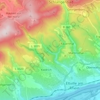
Name: Eltville topographic map, elevation, terrain.
Average elevation: 269 m
Minimum elevation: 79 m
Maximum elevation: 587 m
Other topographic maps
Click on a map to view its topography, its elevation and its terrain.
Gaisgarten
Deutschland > Hessen > Rheingau-Taunus-Kreis > Eltville am Rhein > Hattenheim > Gaisgarten
Gaisgarten, Hattenheim, Eltville am Rhein, Rheingau-Taunus-Kreis, Hessen, 65346, Deutschland
Average elevation: 323 m
Hattenheim
Deutschland > Hessen > Rheingau-Taunus-Kreis > Eltville am Rhein
Hattenheim, Eltville am Rhein, Rheingau-Taunus-Kreis, Hessen, 65347, Deutschland
Average elevation: 261 m