
Ulhasnagar topographic map
Interactive map
Click on the map to display elevation.
About this map
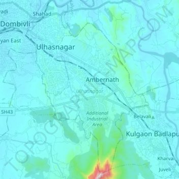
Name: Ulhasnagar topographic map, elevation, terrain.
Location: Ulhasnagar, Thane, Maharashtra, India (19.13432 73.14600 19.25480 73.23347)
Average elevation: 47 m
Minimum elevation: 0 m
Maximum elevation: 767 m
Other topographic maps
Click on a map to view its topography, its elevation and its terrain.
Ambernath
India > Maharashtra > Ulhasnagar > Ambernath
Ambernath, Ulhasnagar, Thane, Maharashtra, India
Average elevation: 55 m