
Lapland topographic map
Interactive map
Click on the map to display elevation.
About this map
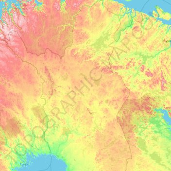
Name: Lapland topographic map, elevation, terrain.
Location: Lapland, Mainland Finland, Finland (65.29248 20.54864 70.09229 30.01567)
Average elevation: 249 m
Minimum elevation: -2 m
Maximum elevation: 1,344 m
Other topographic maps
Click on a map to view its topography, its elevation and its terrain.
Itä-Lapin seutukunta
Itä-Lapin seutukunta, Lapland, Northern Finland, Mainland Finland, Finland
Average elevation: 228 m
Uljua Reservoir
Finland > Northern Finland > Siikalatva
Uljua Reservoir, Kivimäentie, Siikalatva, Haapaveden-Siikalatvan seutukunta, Northern Ostrobothnia, Regional State Administrative Agency for Northern Finland, Northern Finland, Mainland Finland, Finland
Average elevation: 80 m
Lokka reservoir
Finland > Northern Finland > Sodankylä > Sodankylä
Lokka reservoir, Sodankylä, Pohjois-Lapin seutukunta, Lapland, Northern Finland, Mainland Finland, Finland
Average elevation: 264 m
Halti
Finland > Northern Finland > Enontekiö
Halti, Enontekiö, Tunturi-Lapin seutukunta, Lapland, Northern Finland, Mainland Finland, Finland
Average elevation: 1,192 m
Mitti
Finland > Northern Finland > Raahe
Mitti, Raahe, Raahen seutukunta, Northern Ostrobothnia, Regional State Administrative Agency for Northern Finland, Northern Finland, Mainland Finland, Finland
Average elevation: 0 m
Venetjoki
Finland > Northern Finland > Halsua
Venetjoki, Halsua, Kaustisen seutukunta, Keski-Pohjanmaa, Western and Central Finland, Northern Finland, Mainland Finland, 69510, Finland
Average elevation: 131 m