
Fall River topographic map
Interactive map
Click on the map to display elevation.
About this map
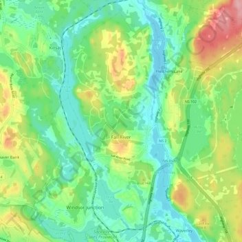
Name: Fall River topographic map, elevation, terrain.
Location: Fall River, Nova Scotia, Canada (44.78279 -63.65456 44.85636 -63.53951)
Average elevation: 61 m
Minimum elevation: 14 m
Maximum elevation: 154 m
Other topographic maps
Click on a map to view its topography, its elevation and its terrain.
Perry Lake
Canada > Nova Scotia > Fall River
Perry Lake, Fall River, Halifax Regional Municipality, Halifax County, Nova Scotia, Canada
Average elevation: 42 m