
Gerolfing Nord topographic map
Interactive map
Click on the map to display elevation.
About this map
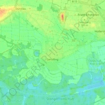
Name: Gerolfing Nord topographic map, elevation, terrain.
Location: Gerolfing Nord, West, Ingolstadt, Bayern, 85049, Deutschland (48.73922 11.30451 48.77532 11.37941)
Average elevation: 374 m
Minimum elevation: 361 m
Maximum elevation: 397 m
Das Pfarrdorf liegt auf einer Höhe von 374 m ü. NN. Im Süden des Ortes befindet sich der Eichenwald mit dem Gerolfinger Weiher (Schafirrsee). Etwa 2 Kilometer vom südlichen Ortsrand entfernt fließt die Donau in östlicher Richtung.