
Dublin topographic map
Interactive map
Click on the map to display elevation.
About this map
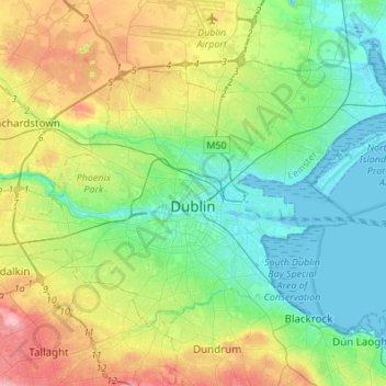
Name: Dublin topographic map, elevation, terrain.
Location: Dublin, County Dublin, Leinster, Irlande (53.29873 -6.38703 53.41054 -6.11488)
Average elevation: 42 m
Minimum elevation: -2 m
Maximum elevation: 131 m
Other topographic maps
Click on a map to view its topography, its elevation and its terrain.
Portraine
Portraine, Fingal, County Dublin, Leinster, K36 W584, Irlande
Average elevation: 4 m
Dublin Fingal West
Dublin Fingal West, County Dublin, Leinster, Irlande
Average elevation: 43 m
Portrane
Irlande > County Dublin > Portrane
Portrane, Fingal, County Dublin, Leinster, K36 V064, Irlande
Average elevation: 3 m
Dún Laoghaire
Dún Laoghaire, Dún Laoghaire-Rathdown, County Dublin, Leinster, A96 T860, Irlande
Average elevation: 21 m