
Make a donation
Southend topographic map
Click on the map to display elevation.
Make a donation
About this map
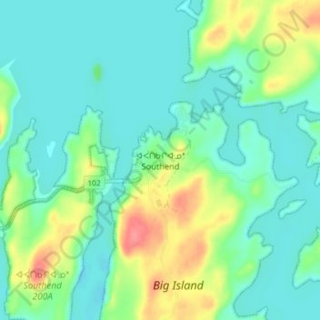
Name: Southend topographic map, elevation, terrain.
Location: Southend, Saskatchewan, Canada (56.30925 -103.25869 56.34925 -103.21869)
Average elevation: 350 m
Minimum elevation: 331 m
Maximum elevation: 398 m
Make a donation
Other topographic maps
Click on a map to view its topography, its elevation and its terrain.
Saskatoon
Saskatoon lies on a long belt of rich, potassic chernozem in middle-southern Saskatchewan and is found in the aspen parkland biome. The lack of surrounding mountainous topography gives the city a relatively flat grid, though the city does sprawl over a few hills and into a few valleys. The lowest point in the…
Average elevation: 504 m
Regina
Unlike other planned cities in the Canadian West, on its treeless flat plain Regina has few topographical features other than the small spring run-off, Wascana Creek. Early planners took advantage of such opportunity by damming the creek to create a decorative lake to the south of the central business district…
Average elevation: 582 m
Make a donation
Make a donation
Make a donation
Make a donation
Make a donation
Make a donation
Make a donation
Make a donation
Make a donation
Make a donation
Make a donation
Make a donation
Make a donation
Make a donation
Make a donation
Make a donation
Make a donation
Make a donation
Make a donation
Make a donation
Make a donation
Make a donation
Make a donation
Make a donation
Make a donation