
Thank you for supporting this site ❤️
Make a donation
Make a donation
Villavente topographic map
Click on the map to display elevation.
Thank you for supporting this site ❤️
Make a donation
Make a donation
About this map
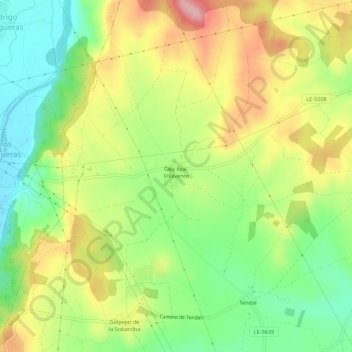
Name: Villavente topographic map, elevation, terrain.
Location: Villavente, Valdefresno, León, Castilla y León, 24195, España (42.59736 -5.52688 42.63736 -5.48688)
Average elevation: 900 m
Minimum elevation: 831 m
Maximum elevation: 984 m
Thank you for supporting this site ❤️
Make a donation
Make a donation
Other topographic maps
Click on a map to view its topography, its elevation and its terrain.