
Make a donation
Nallingen topographic map
Click on the map to display elevation.
Make a donation
About this map
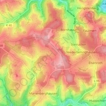
Name: Nallingen topographic map, elevation, terrain.
Average elevation: 266 m
Minimum elevation: 176 m
Maximum elevation: 322 m
Make a donation
Other topographic maps
Click on a map to view its topography, its elevation and its terrain.
Kurpark Nümbrecht
Deutschland > Nordrhein-Westfalen > Oberbergischer Kreis > Nümbrecht > Ödinghausen
Average elevation: 280 m
Schloss Homburg
Deutschland > Nordrhein-Westfalen > Oberbergischer Kreis > Nümbrecht > Homburg-Bröl > Unter der Hardt
Average elevation: 257 m
Guxmühlen
Deutschland > Nordrhein-Westfalen > Oberbergischer Kreis > Nümbrecht > Marienberghausen
Auf der Hardt | Abbenroth | Ahebruch | Ahlbusch | Alsbach | Altennümbrecht | Bierenbachtal | Breunfeld | Benroth | Berkenroth | Birkenbach | Breitewiese | Brünglinghausen | Bruch | Büschhof | Buch | Distelkamp | Drinsahl | Elsenroth | Erlinghausen | Friedenthal | Gaderoth | Gerhardsiefen | Geringhausen |…
Average elevation: 248 m