
Lake Wairarapa topographic map
Interactive map
Click on the map to display elevation.
About this map
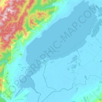
Name: Lake Wairarapa topographic map, elevation, terrain.
Average elevation: 106 m
Minimum elevation: -4 m
Maximum elevation: 819 m
Other topographic maps
Click on a map to view its topography, its elevation and its terrain.
Lower Hutt
Nueva Zelanda > Wellington > Lower Hutt
Lower Hutt, Lower Hutt City, Wellington, 5010, Nueva Zelanda
Average elevation: 173 m
1015
1015, Kapiti Coast District, Wellington, Nueva Zelanda
Average elevation: 777 m
Wellington
Nueva Zelanda > Wellington > Wellington City
Wellington, Wellington City, Wellington, 6011, Nueva Zelanda
Average elevation: 85 m