
Sallandse Heuvelrug topographic map
Interactive map
Click on the map to display elevation.
About this map
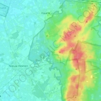
Name: Sallandse Heuvelrug topographic map, elevation, terrain.
Location: Sallandse Heuvelrug, Haarle, Hellendoorn, Overijssel, Nederland (52.29464 6.36328 52.36874 6.46812)
Average elevation: 22 m
Minimum elevation: 6 m
Maximum elevation: 70 m
Other topographic maps
Click on a map to view its topography, its elevation and its terrain.
Haarle
Nederland > Overijssel > Haarle
Haarle, Overijssel, Nederland, 7448, Nederland
Average elevation: 17 m