
Thank you for supporting this site ❤️
Make a donation
Make a donation
Seine-Maritime topographic map
Click on the map to display elevation.
Thank you for supporting this site ❤️
Make a donation
Make a donation
About this map
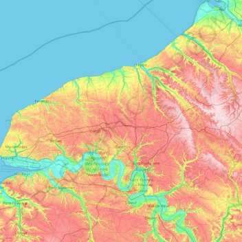
Name: Seine-Maritime topographic map, elevation, terrain.
Location: Seine-Maritime, Normandy, Metropolitan France, France (49.25067 0.06577 50.07581 1.79077)
Average elevation: 85 m
Minimum elevation: -3 m
Maximum elevation: 248 m
Thank you for supporting this site ❤️
Make a donation
Make a donation
Other topographic maps
Click on a map to view its topography, its elevation and its terrain.