
Kapellen topographic map
Interactive map
Click on the map to display elevation.
About this map
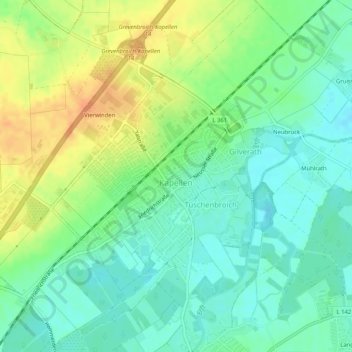
Name: Kapellen topographic map, elevation, terrain.
Average elevation: 57 m
Minimum elevation: 41 m
Maximum elevation: 80 m
Other topographic maps
Click on a map to view its topography, its elevation and its terrain.
Grevenbroich
Deutschland > Nordrhein-Westfalen > Grevenbroich
Grevenbroich, Rhein-Kreis Neuss, Regierungsbezirk Düsseldorf, Nordrhein-Westfalen, 41515, Deutschland
Average elevation: 57 m
Reid
Deutschland > Nordrhein-Westfalen > Grevenbroich
Reid, Grevenbroich, Rhein-Kreis Neuss, Regierungsbezirk Düsseldorf, Nordrhein-Westfalen, 41516, Deutschland
Average elevation: 52 m