
Thank you for supporting this site ❤️
Make a donation
Make a donation
Easebourne topographic map
Click on the map to display elevation.
Thank you for supporting this site ❤️
Make a donation
Make a donation
About this map
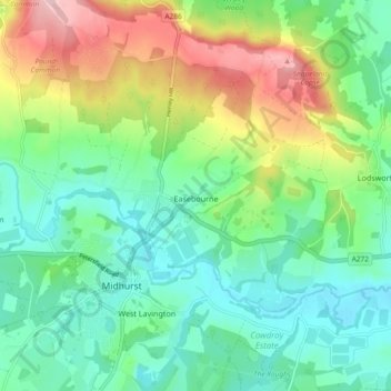
Name: Easebourne topographic map, elevation, terrain.
Location: Easebourne, Chichester, West Sussex, England, United Kingdom (50.96837 -0.75454 51.02688 -0.69131)
Average elevation: 72 m
Minimum elevation: 11 m
Maximum elevation: 203 m
Thank you for supporting this site ❤️
Make a donation
Make a donation
Other topographic maps
Click on a map to view its topography, its elevation and its terrain.