
Thank you for supporting this site ❤️
Make a donation
Make a donation
Schwarzer Mann topographic map
Click on the map to display elevation.
Thank you for supporting this site ❤️
Make a donation
Make a donation
Schwarzer Mann
Der Schwarze Mann bei Buchet-Halenfeld im rheinland-pfälzischen Eifelkreis Bitburg-Prüm ist mit 697,8 m ü. NHN nach einem nahen Gipfel mit 699,1 m Höhe die zweithöchste Erhebung der Schneifel.
Thank you for supporting this site ❤️
Make a donation
Make a donation
About this map
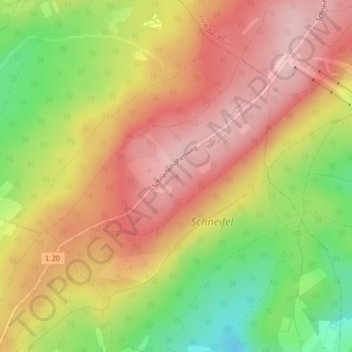
Name: Schwarzer Mann topographic map, elevation, terrain.
Average elevation: 621 m
Minimum elevation: 510 m
Maximum elevation: 702 m
Thank you for supporting this site ❤️
Make a donation
Make a donation